<Imageotag/>
Imageotag is a precision field camera application for Android™ V1.5+ devices.
*NOTE* Professional users are encouraged to upgrade to Media Mapper Mobile
http://market.android.com/details?id=com.MediaMapper.Mobile
As well as providing Imageotag features for the latest phones & tablets Media Mapper Mobile supports
* Bluetooth GPS logging
* Remote trigger Nikon SLR via Blue2Can attachment
* LTI TruePulse 360B/R Laser Range Finder measurements
* Connect 4 Android devices for multi device photo capture
* Integrate with Red Hen Systems GIS software
For further details see
http://market.android.com/details?id=com.MediaMapper.Mobile
or contact http://www.redhensystems.com
Imageotag creates standard geo-tagged jpeg camera images as well as -
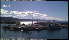 * Creates a second 16:9 wide screen jpeg camera image and displays around the frame border all available sensor telemetry
including GPS latitude, longitude, altitude, accuracy, bearing, speed, date & time, Compass, pitch & roll,
clock date & time, network location, accelerometer & magnetic compass as well as proximity,
light lux level & temperature.
* Creates a second 16:9 wide screen jpeg camera image and displays around the frame border all available sensor telemetry
including GPS latitude, longitude, altitude, accuracy, bearing, speed, date & time, Compass, pitch & roll,
clock date & time, network location, accelerometer & magnetic compass as well as proximity,
light lux level & temperature.
* Supports the creation of images sequences in two modes including standard time delay as well as unique GPS distance mode where consecutive images are triggered by gps movement.
* Creates Google Earth™ tours from image sequences that can include audio commentary as well as images and location details.
* EXIF data is included in both the original and wide screen jpeg images on supported Android™ V2+ devices.
* Image views including scrolling lists, contact sheets with thumbnail images & slide shows.
* Map views including thumbnail image maps and map view slide shows.
* Ability to change all supported standard camera & image settings including quality, size, effects, focus, flash, night shot, white balance & zoom.
* Record audio commentary for each image as well as add image comments.
* Image sensor telemetry is recorded in SQLITE database as well to external XML files.
An independent review of Imageotag is available on the Androgeoid and Free Geography Tools websites.
The following pages describe Imageotag in detail -
Camera Preview
Image View
Map View
Settings
Tutorial - How to make a Google Earth Tour
Download Imageotag
EULA- End User License Agreement
FAQ - Frequently asked questions
Release Notes, Known Issues
Contact Imageotag
Privacy
Last updated: Sunday 09/02/2014 17:07:00 GMT+11:00
© All rights reserved.
Android, Google Earth and Google Maps are a trademarks of Google Inc.